Showing 24 items matching loddon river
-
 Tarnagulla History Archive
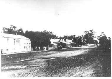
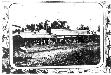
Photographs: Buildings in Newbridge near Loddon River bridge, Buildings in Newbridge near Loddon River bridge, 1908 (original image)
... Photographs: Buildings in Newbridge near Loddon River...Buildings in Newbridge near Loddon River bridge...loddon river... buildings in the eastern approach to the Loddon River bridge... in Newbridge near Loddon River bridge Buildings in Newbridge near ...Depicts at left, Petersen's bakery, a store shed, Simpson's storekeepers and Simpson's Hotel. Hollands blacksmith shop & wheelwrights on right opposite bakery. Murray Comrie Collection. Three copies of a monochrome photograph, image depicts buildings in the eastern approach to the Loddon River bridge at Newbridge This is a fairly dark copy of an older original. Copy probably made by Murray Comrie in the 1960s.newbridge, loddon river, bridge, shops, stores, businesses, hotels, simpsons, petersens, bakery -
 Tarnagulla History Archive
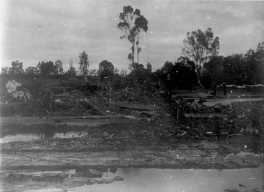
Photographs: Loddon River, Newbridge after flood, Loddon River, Newbridge after flood, 1909 (original image)
... Photographs: Loddon River, Newbridge after flood...Loddon River, Newbridge after flood...loddon river... the area near Loddon River at Newbridge after major flood in 1909... Commercial Rd Tarnagulla goldfields Photographs: Loddon River ...On 20th August,1909 the Laanecoorie Weir broke away and released 18.3 million cubic metres of water through the opening and causing severe damage to all towns downstream. At Newbridge, Petersen's bakery collapsed and Simpson's Store and Hotel flooded to the roof. The billiard table was later found in a tree five miles down the Loddon near Learmonth. Murray Comrie Collection. Two copies of a monochrome photograph, image depicts the area near Loddon River at Newbridge after major flood in 1909. This is a very grainy and dark copy of an older original. Copy probably made by Murray Comrie in the 1960s.newbridge, loddon river, flood, bridge -
 Tarnagulla History Archive
Photographs: Loddon River, Newbridge after flood, Loddon River, Newbridge after flood, 1909 (original image)
... Photographs: Loddon River, Newbridge after flood...Loddon River, Newbridge after flood...loddon river... of damaged bridge in the area near Loddon River at Newbridge after... Commercial Rd Tarnagulla goldfields Photographs: Loddon River ...On 20th August,1909 the Laanecoorie Weir broke away and released 18.3 million cubic metres of water through the opening and causing severe damage to all towns downstream. At Newbridge, Petersen's bakery collapsed and Simpson's Store and Hotel flooded to the roof. The billiard table was later found in a tree five miles down the Loddon near Learmonth. Murray Comrie Collection. Two copies of a monochrome photograph, image part of damaged bridge in the area near Loddon River at Newbridge after major flood in 1909. This is a very grainy and dark copy of an older original. Copy probably made by Murray Comrie in the 1960s.newbridge, loddon river, flood, bridge -
 Tarnagulla History Archive
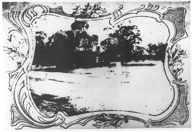
Postcard - Photographic postcard: Loddon River, Newbridge near Tarnagulla, c. 1900-1920s
... Photographic postcard: Loddon River, Newbridge near... image depicting the Loddon River at Newbridge. ... the Loddon River at Newbridge. Williams Family Collection. tarnagulla ...Williams Family Collection. Monochrome photographic postcard, Reids Series No.5. Front image depicting the Loddon River at Newbridge. tarnagulla -
 Tarnagulla History Archive
Photograph: Debris after flood, Newbridge, Debris after flood, Newbridge, 1909 (original image)
... loddon river... near Loddon River at Newbridge after major flood in 1909... depicting debris in the area near Loddon River at Newbridge after ...On 20th August, 1909 the Laanecoorie Weir broke away and released 18.3 million cubic metres of water through the opening and causing severe damage to all towns downstream. At Newbridge, Petersen's bakery collapsed and Simpson's Store and Hotel flooded to the roof. The billiard table was later found in a tree five miles down the Loddon near Learmonth. Murray Comrie Collection. Monochrome photograph, image depicting debris in the area near Loddon River at Newbridge after major flood in 1909. This is a very dark copy of an older original. Copy probably made by Murray Comrie in the 1960s.newbridge, loddon river, flood -
 Tarnagulla History Archive
Photograph: Simpsons Store and Hotel, Newbridge after flood, Simpsons Store and Hotel, Newbridge after flood, 1909 (original image)
... loddon river... in the area near Loddon River at Newbridge after major flood in 1909... in the area near Loddon River at Newbridge after major flood in 1909 ...In this image, store merchandise, including drapery, is hung out to dry after the flood. On 20th August,1909 the Laanecoorie Weir broke away and released 18.3 million cubic metres of water through the opening and causing severe damage to all towns downstream. At Newbridge, Petersen's bakery collapsed and Simpson's Store and Hotel flooded to the roof. The billiard table was later found in a tree five miles down the Loddon near Learmonth. Murray Comrie Collection. Monochrome photograph, image depicting buildings in the area near Loddon River at Newbridge after major flood in 1909. This is a very grainy and dark copy of an older original. Copy probably made by Murray Comrie in the 1960s.newbridge, loddon river, flood, simpson, stores, hotels -
Tarnagulla History Archive
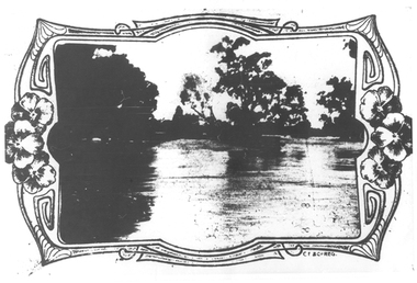
Postcard: River Loddon, Laanecoorie
... Postcard: River Loddon, Laanecoorie... Commercial Rd Tarnagulla goldfields Postcard: River Loddon ...David Gordon Collection. -
Tarnagulla History Archive
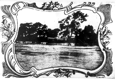
Postcard: River Loddon, Laanecoorie
... Postcard: River Loddon, Laanecoorie... Commercial Rd Tarnagulla goldfields Postcard: River Loddon ...David Gordon Collection. -
 Victorian Aboriginal Corporation for Languages
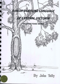
Book, John Tully, Djadja Wurrung language of Central Victoria : including place names, 1997
... Loddon River... Mount Kooyoora Mount Moliagul Loddon River Dunolly Yuinhup King ...A dictionary of the Djadja Wurrung language including a short introduction with pronunciation and grammatical information. Includes Djadja Wurrung-English and English-Djadja Wurrung sections, and a section on Djadja Wurrung placenames.Maps, b&w illustrations, word listsdjadja wurrung, central victoria, mount franklin, mount tarrengower, mount kooyoora, mount moliagul, loddon river, dunolly, yuinhup, king tommy, place names, grammar -
 Victorian Aboriginal Corporation for Languages
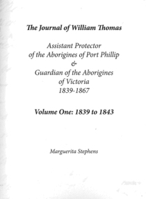
Book, Marguerita Stephens, The journal of William Thomas : assistant protector of the Aborigines of Port Phillip &? guardian of the Aborigines of Victoria 1839 - 1867 : volume one : 1839 to 1843, 2014
... Loddon River... Dja wurrung Avoca Loddon River Bangerang Pangerang Pangeran ...This series presents 28 years of Thomas' journals, transcribed and annotated by Dr Marguerita Stephens (Vols 1-3). Vol 4 provides a substantial collection of Thomas' records of Kulin language - some reworked from earlier transcriptions by Dr Stephen Morey. For nearly three decades William Thomas chronicled his life and work with Aboriginal Victorians through his daily journal entries. Now this four volume set, comprehensively indexed and extensively annotated, shines new light on the history of race relations in Australia. Thomas' detailed observations give a rare insight into the process of cultural continuity and collapse, and the agency of Victorian Aboriginal leaders in social and economic interactions with settlers and colonial administrations in a time of great social upheaval. This first-hand account repopulates Victorian history, paying respect to the work, play and lives of the Aboriginal men and women who emerge from the pages of Thomas' journal.document reproductions, b&w illustrationswurundjeri, woiwurrung, woi wurrung, yarra, waverong, wavarong, waborong, warwarong, warworong, waworong, wa woo rong, wouvarong, wavorong, port phillip, boon wurrung, mount macedon, bacchus marsh, backhouse marsh, boonurrong, boonurong, boonmerong, bonwarong, boomerong, boonvarong, boonerong, bunurong, boonrong, boonworng, boonurong, boonwrung, boonurgs, taungurung, goulbourn, tongorong, devils river tribe, wathaurong, wadawurrung, barrabool, barabool, wattowrong, william thomas, geelong, ballarat, mount buninyong, booningong, leigh river tribe, dja dja wurrung, avoca, loddon river, bangerang, pangerang, pangeran, pangarran, pangarans, parngarangs, ovens river tribe, broken river tribe, gunai kurnai, omeo, monaro -
 Victorian Aboriginal Corporation for Languages
Book, Marguerita Stephens, The journal of William Thomas : assistant protector of the Aborigines of Port Phillip &? guardian of the Aborigines of Victoria 1839 - 1867 : volume two: 1844 to 1853, 2014
... Loddon River... Dja wurrung Avoca Loddon River Bangerang Pangerang Pangeran ...This series presents 28 years of Thomas' journals, transcribed and annotated by Dr Marguerita Stephens (Vols 1-3). Vol 4 provides a substantial collection of Thomas' records of Kulin language - some reworked from earlier transcriptions by Dr Stephen Morey. For nearly three decades William Thomas chronicled his life and work with Aboriginal Victorians through his daily journal entries. Now this four volume set, comprehensively indexed and extensively annotated, shines new light on the history of race relations in Australia. Thomas' detailed observations give a rare insight into the process of cultural continuity and collapse, and the agency of Victorian Aboriginal leaders in social and economic interactions with settlers and colonial administrations in a time of great social upheaval. This first-hand account repopulates Victorian history, paying respect to the work, play and lives of the Aboriginal men and women who emerge from the pages of Thomas' journal.document reproductionswurundjeri, woiwurrung, woi wurrung, yarra, waverong, wavarong, waborong, warwarong, warworong, waworong, wa woo rong, wouvarong, wavorong, port phillip, boon wurrung, mount macedon, bacchus marsh, backhouse marsh, boonurrong, boonurong, boonmerong, bonwarong, boomerong, boonvarong, boonerong, bunurong, boonrong, boonworng, boonurong, boonwrung, boonurgs, taungurung, goulbourn, tongorong, devils river tribe, wathaurong, wadawurrung, barrabool, barabool, wattowrong, william thomas, geelong, ballarat, mount buninyong, booningong, leigh river tribe, dja dja wurrung, avoca, loddon river, bangerang, pangerang, pangeran, pangarran, pangarans, parngarangs, ovens river tribe, broken river tribe, gunai kurnai, omeo, monaro -
 Victorian Aboriginal Corporation for Languages
Book, Marguerita Stephens, The journal of William Thomas : assistant protector of the Aborigines of Port Phillip &? guardian of the Aborigines of Victoria 1839 - 1867 : volume three: 1854 to 1867, 2014
... Loddon River... Dja wurrung Avoca Loddon River Bangerang Pangerang Pangeran ...Annotation. This series presents 28 years of Thomas' journals, transcribed and annotated by Dr Marguerita Stephens (Vols 1-3). Vol 4 provides a substantial collection of Thomas' records of Kulin language - some reworked from earlier transcriptions by Dr Stephen Morey. For nearly three decades William Thomas chronicled his life and work with Aboriginal Victorians through his daily journal entries. Now this four volume set, comprehensively indexed and extensively annotated, shines new light on the history of race relations in Australia. Thomas' detailed observations give a rare insight into the process of cultural continuity and collapse, and the agency of Victorian Aboriginal leaders in social and economic interactions with settlers and colonial administrations in a time of great social upheaval. This first-hand account repopulates Victorian history, paying respect to the work, play and lives of the Aboriginal men and women who emerge from the pages of Thomas' journal.document reproductionswurundjeri, woiwurrung, woi wurrung, yarra, waverong, wavarong, waborong, warwarong, warworong, waworong, wa woo rong, wouvarong, wavorong, port phillip, boon wurrung, mount macedon, bacchus marsh, backhouse marsh, boonurrong, boonurong, boonmerong, bonwarong, boomerong, boonvarong, boonerong, bunurong, boonrong, boonworng, boonurong, boonwrung, boonurgs, taungurung, goulbourn, tongorong, devils river tribe, wathaurong, wadawurrung, barrabool, barabool, wattowrong, william thomas, geelong, ballarat, mount buninyong, booningong, leigh river tribe, dja dja wurrung, avoca, loddon river, bangerang, pangerang, pangeran, pangarran, pangarans, parngarangs, ovens river tribe, broken river tribe, gunai kurnai, omeo, monaro -
 Ballarat Heritage Services
Photograph - Image, Guildford, Victoria, 1867
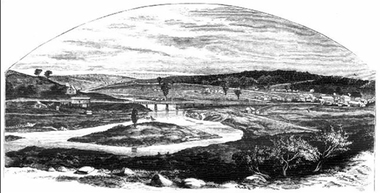
... loddon river...) guildford loddon river ...Black and white image of Guildford, near Castlemaine, VictoriaGUILDFORD Is a small township situated at the junction of Campbell's Creek and the Loddon. It is about seven miles from Castlemaine, on the road from that town to Ballaarat and Daylesford. The land near the Loddon is very rich, and as a large number both of theoretical and practical miners believe that a rich goldfield underlies the surface basalt, there is every probability of Guildford being ere an important goldfield. A large area of land in the neighbourhood has been already worked, principaIy by Chinamen, who until very recently mustered in great force in the locality. (Illustrated Adelaide Post, 23 March 1867)guildford, loddon river -
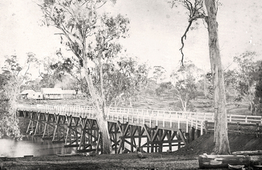
 Tarnagulla History Archive
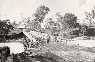
Photograph of the newly completed bridge at Newbridge, Victoria, c.1894, The newly completed bridge at Newbridge, Victoria, c.1894, 1894
... loddon river...-preserved original. newbridge bridge loddon river infrastructure ...Murray Comrie Collection. This photograph is a well-preserved original. Monochrome photograph depicting the newly completed wooden bridge at Newbridge, Victoria. Thirteen men are in the image, standing at one end of the bridge. These are most likely men who worked on constructing the bridge. Position of photographer is on the west bank of the Loddon, looking east.newbridge, bridge, loddon river, infrastructure, construction, roads, workers, farms, people -
 Tarnagulla History Archive
Photograph of the newly completed bridge at Newbridge, Victoria, c.1894, The newly completed bridge at Newbridge, Victoria, c.1894, 1894
... loddon river... of photographer is on the east bank of the Loddon, looking west toward ...Murray Comrie Collection. This photograph is a well-preserved original. Monochrome photograph depicting the newly completed wooden bridge at Newbridge, Victoria. Position of photographer is on the east bank of the Loddon, looking west toward the present day Newbridge Pub.newbridge, bridge, loddon river, infrastructure, construction, roads, businesses, buildings -
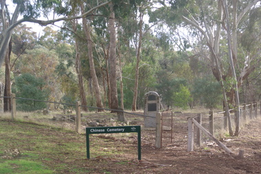 Ballarat Heritage Services
Photograph - Colour, Vaughan Chinese Cemetery, 2017, 16/07/2017
... of Fryers Creek and Loddon River). The location of the cemetery... and Loddon River). The location of the cemetery was chosen because ...Established during the great Mount Alexander alluvial gold rush of 1852-54 the cemetery is located on a small hill overlooking one of the richest spots on the goldfield (the junction of Fryers Creek and Loddon River). The location of the cemetery was chosen because it was a convenient piece of ground where gold was not likely to be discovered, and burials were mainly of Chinese miners. It remained in use until 1857. The cemetery was restored in 1929 using money raised within the Chinese communities of Bendigo and Castlemaine. Colour photograph of the Chinese Cemetery at Vaughan. vaughan, vaughan springs, vaughan chinese cemetery, chinese -
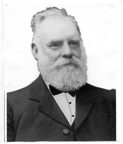 Tarnagulla History Archive
Photograph of John Shields Simpson, circa 1880s
... severely damaged in floods of the Loddon River in 1909. He... damaged in floods of the Loddon River in 1909. He was elected ...Murray Comrie Collection. Information written by Murray Comrie: John Shields Simpson was born in Scotland in 1831, came to Victoria in 1853 and after mining for a time took up land at what was later to be the Nick O'Time Lead at Poseidon. He took up a store at Newbridge and in 1905 built a hotel alongside the store. Both were severely damaged in floods of the Loddon River in 1909. He was elected to the Tarnagulla Borough Council in 1882 and retained his seat until 1915 when he resigned. He was Mayor of the Borough on five occasions. Monochrome photographic portrait of a bearded man.Accompanying note identifies subject as John Shields Simpson.borough of tarnagulla, john shields simpson, mayor, council, local government, local people, newbridge, store, hotel -
 Ballarat Heritage Services
Photograph - Photograph - Colour, Clare Gervasoni, Tarilta, 2017, 16/07/2017
... located where the Kangaroo Creek enters the Loddon River... located where the Kangaroo Creek enters the Loddon River ...Tarilta is a rural locality and former gold-mining town 12 km south of Castlemaine, 4 km north-west of Guildford and 3 km north-east of Vaughan. The last gold mining activity took place around the 1880s. It was originally Kangaroo Flat, being located where the Kangaroo Creek enters the Loddon River. It was surveyed and named in 1864. Gold was discovered at Tarilta in 1853. The Tarilta School was opened in 1860 in a Wesleyan chapel, and closed i n1925. In 1864 a township was surveyed and named Tarilta, the word being derived from an Aboriginal expression thought to mean kangaroo. In 1865 Bailliere’s Victorian gazetteer described Tarilta as being an alluvial and quartz gold-mining town with three quartz-crushing mills, three horse-puddling machines and two hotels. The elevated nature of the land around Tarilta made it accessible only by horse and dray, or on horseback. Colour photograph of Tarilta in Central Victoria. tarilta, central victoria, landcape -
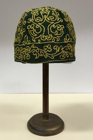 Kew Historical Society Inc
Headwear - Green Cotton & Yellow Silk Ribbon Smoker's or Lounge Cap, 1860s
... Creek and the Loddon River, so perhaps the cap might have... and the Loddon River, so perhaps the cap might have belonged to a member ...The context in which the hat was made and worn assists in establishing its potential historic significance. 'Bailliere's Victorian Gazetteer and Road Guide containing the most recent and accurate information as to every place in the Colony' (1870), describes the village of Vaughan as being located on the road from Daylesford to Castlemaine. In 1870 the Vaughan was deemed to be entirely a gold mining area, gold having been discovered in the district in 1853. Intriguingly the entry in the Gazetteer claims that the electoral division of Vaughan began at the junction of the Middleton Creek and the Loddon River, so perhaps the cap might have belonged to a member of a significant local family. In 1870, Vaughan had a population of about 1000 persons and included almost 300 dwellings. Articles from newspapers, published on Trove refer frequently to a Mr Middleton as a litigant in court cases before the Vaughan Court in the 1860s. By the 1870s, the Mt Alexander Mail, in an article on ‘Mining: The Pioneer Wheel’ describes the success of Mr Middleton and his Middleton’s Reef Gold Quartz Mining Company, which had built the largest water wheel in the Colony. The wheel was 20’ in diameter and 2’ wide. Quartz mining as practiced by companies such as Middleton’s had become necessary after the exhaustion of alluvial quartz mining deposits in the 1860s. So we can probably establish a link between the cap and a significant mining identity in the period in which the article was made. The historical significance of the cap is only one part of the story. Caps such as the Middleton example can also be items of aesthetic significance as they were typically, examples of women’s work, using published patterns in magazines such as the Ladies Home Magazine. While women might follow or adapt a published pattern, their choice of materials reflected what was available locally. The fine hand stitching on this example is evidence of high quality domestic needlework. The maker crafted the cap from five triangular pieces of cotton cloth, each piece lined with a faded yellow net. The net provides some stiffening for the cap and has a functional purpose in that it anchors the hand-stitched, looped design of yellow silk ribbon that decorates the surface of the cap. Gentleman’s smoking (lounging) cap believed to have been made in c.1860-69. The conical hat is made of a dark green cotton fabric embroidered with narrow ribbon of a paler green silk. The unlined rimless hat is made of four pieces of fabric. There is no evidence of the hat at one stage featuring a tassle. The original donation record noted that the cap had been made for, and was worn by, a Mr Middleton, of Vaughan in Central Victoria. Nilhats, smokers hats, men's clothing -
Tatura Irrigation & Wartime Camps Museum
Photograph, 1920
Taken by photographer for State Rivers and Water Supply Commission.Medium sized black and white photograph. Campaspe Siphon under construction / Three engineers stand on top of reinforced form work for concrete pour on culverts / One workman emptying wheelbarrow whilst on right another watches / Group of men (top left) work under leaning tree.victorian state rivers and supply commission, east loddon irrigation system, campaspe siphon -
 Victorian Aboriginal Corporation for Languages
Book, Ian D Clark, The papers of George Augustus Robinson, Chief Protector, Port Phillip Aboriginal Protectorate : volume four : annual and occasional reports : 1841-1849, 2001
... Rivoli Bay Mount Gambier Murray River Swan Hill Goulburn Loddon ...This is a collection of Official Reports from the Chief Protector of Aborigines. It includes expedition reports to the Western Interior, 1841, a journey of 1,100 miles to the tribes of the North West and Western Interior, 1845 and Annual Reports.document reproductionsport phillip protectorate, george augustus robinson, western district, noorat, lake boloke, lake bolac, lake corangemite, portland, koroit, koonong wootong, burrumbeep, tarecurrumbeet, wimmera, lake hindmarsh, rivoli bay, mount gambier, murray river, swan hill, goulburn, loddon, mount rouse -
Whitehorse Historical Society Inc.
Map, Yarra River, n.d
Copy of fold-out map 'Loddon 25' included in 'Lilydale', by Grace Aveling. Based on T.H. Nutt's original survey of the Yarra River, 1839.aveling, grace, nutt, t.h., yarra river -
 Federation University Historical Collection
Book, Memoirs of the Geological Survey of Victoria; No 18, Clay and Shale Deposits of Victoria, 1952
Grey soft covered book with red tape spine. The 76 pages clay deposits, composition of Victorian clays, clay localities, granitic clays, Residual Clays, Clay-Shales, Jurassic clay shales.r a keble, senior field geologist, j c watson, chief chemist, d e watson, chief government geologist, g c moss, minister of mines, mallee plains, avoca valley, loddon valley, campaspe valley, goulburn valley, kiewa, mitta, glenelg valley, pitfield valley, otway area, moorabool valley, darley fireclay, campbellfield clay, latrobe river valley, hendley, ball clays, felspars, pegmatities, quartz, pakenham fireclay, bulla china clay, kaolin, terracotta, stoneware, ballan dyke-belt, egerton, gordon, ballan, llandeilo, colbrook, elaine, lal lal, maryborough, ballarat, ringwood, siliceous clay, stawell, dromana, ptways, bulla, pyalong china clay, linton china clay, wedderburn clays, lal lal china clays, ballan dyke belt, reginald callister, knight's koalin pottery, china clay, ferdinand krause, clarendon, bittern, frichot, hunt's dam, vaughan, rosenow, hickey, malone, claypits, ballarat dyke belt, stawell dyke belt, maryborough dyke belt, guildford, daylesford, ovens valley